
2018 CDT ContinentaDivide Trail Mexiko - Kanada NM - CO
- Peter van der Gugten
- Sep 13, 2018
- 28 min read
10.5
CDT Continental Divide Trail The adventure begins
We arrive in Albequerque around 2 p.m. and stable our horses at Silver Spurs. In the evening we celebrate Mark's graduation from university. At the party, I break off part of a tooth. Due to my tight schedule, I have to go to the dentist. I am kindly admitted at 12 noon and have to wait 30 minutes. The dentist wants to do x-rays and the like, but I manage to convince him that I just need a filling for the gaping hole in my tooth, and if it doesn't hold for 6 months, I'll take care of it then. After doing some more shopping and Mark getting ready, we drove down to Boot Heel, as this area down here is called. We spent the night at the Silver Spur Ranch.


11.5.
It's a dry, lonely place here in Antelope Wells. While loading the horses for the last time, Apachee hit his head against my forehead and caused two unpleasant bumps. Luckily my glasses weren't damaged. But I kind of look like a devil in disguise. The men from the border patrol are very helpful and advise us to ride to the Menonites, where we can ask to spend the night. We start the ride at 11 a.m. and trot the 25 km to the Mennonite farm, where we are warmly welcomed. Only fences, gates and the customs building for border control on the US and Mexican sides. With us were Jürgen and Anita, a German-American couple who agreed to drive the trailer and provide us with food and water for the horses.


12.5.
These Menonites are a great people. They invited us to stay in their guest trailer and insisted on feeding our horses for free. We spent the evening with them (three families with children) and it turns out they were from Mexico, moved to Canada (BC) and then came to Texas, now here in New Mexico where they farm a 20,000 acre corn farm. We get permission to ride across their land, allowing us to avoid the hot tar road. After lunch, we hit the CDT trail coming from the east and followed it, which turned out to be a long distance. Instead of the 15 km I had planned, it was more like 40, so we ended up covering 65 km on this hot and dry day.
Argentina had prepared me well, but the dryness and the dust here really got to me. Each of us carried 1 liter of water and had to be refilled at every opportunity. We arrived at the camp at 7pm.


13.5.
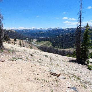
We reached a plateau from where we could see the sheer immensity of the land. The sheer size of the dimensions could be frightening. The cactus is in bloom, but there is no water in several wells along the road. At 3pm we reach the official CDT trail again and camp on BLM land. After yesterday's 65 km, it was 38 km today. The heat is exhausting.


14.5.
On the way to Sepra. After talking to some ranchers, it's clear that nobody wants riders crossing their land. The only recommendation we got was to follow the old railroad track. We later read that the owner of this land is not keen on the CDT route either. But anyway, instead of going to Lordsburg and pounding lots of tar roads, we opted for the railroad route to Sepra. We arrived at the village, which consisted of two houses, around 12am. and arranged for the horses to be stabled in an empty corral next to the gift store, the village. The cattle farmer's son, who had been contacted by the shopkeeper, came by to check on us and the cows behind the corall and everything was fine.


15.5.
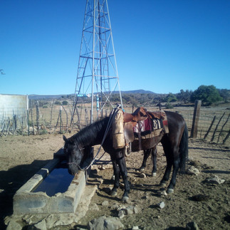
We have covered around 160 km in these days and get up every morning at 5 am and start our journey at 7.30 am. The days are long and tiring. It's a hilly landscape that used to be covered with about 700 small ponds, but 90% of them have dried up. At Spade Fork Ranch, we watered the horses and rode another 38 km until we set up camp.


16.5.
We camped at John's Bull Corall and rode to Wihite Signal the next day, where Juergen was waiting to transport us to Silver City, where we were hosted by Doug Dexter and his wife, the president of the Ghila Chapter of the Backcountry Horsemen. We spent a very nice evening together and sorted our things, because Jürgen was leaving us to drive the truck and trailer back to Colorado. Doug grilled the steaks on a plow slice along with tortillias and sour cream. After some conversation with Doug, we decided to follow his advice and take the Twin Peak Trail to Signal Mountain and then turn back onto the CDT.


17.5.
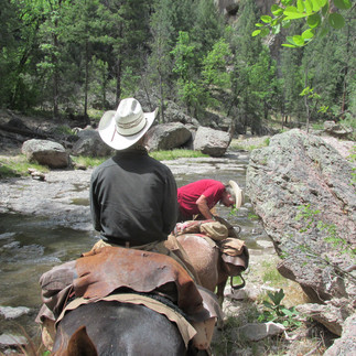
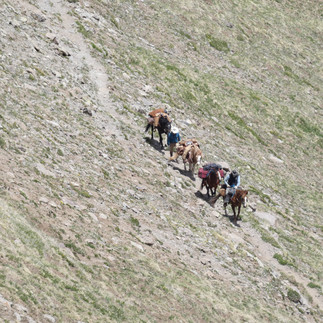
After four seemingly endless days in the "desert", the word "river and canyon" had a very attractive ring to it. We rode along the path that led to the CDT and came across some lovely little streams where the horses were once again eating soft green grass. The trail zigzagged through woods and ended at Highway 15, where we started on the Tad Pool Ridge Trail, 8.5 miles to Sheep Creek Canyon. As it was only 3pm, we decided to go for it. A decision we regretted, as the trail was in poor condition and the 15 km would not end. Up and down we led the horses on a small single trail and we had dozens of trees to climb around or over. Just before dark, we finally came to Tad Pool Lake, where a black bear, whose tracks and droppings we had seen on the trail, was taking a bath. As we approached, he ran off and we didn't see him again. Deets was tied to a stake in the ground and the other three roamed the area inside the electric fence.


18.5.
The horses are behaving very well. Their urge to hide and run away has turned into an eagerness to be with us and move on. The only problems we have are that they don't like to be led. Except for Kiowa. We camp outside every night, with just a sleeping bag and mat. We cook on a gas stove as fires are not allowed. It's never been this dry in the last 35 years and we might have trouble finding grass further north. We descend from Tad Pool Lake and reach Sheep Creek Corall, where we fill up with fresh water and reach the Gila River around 2 pm. After three river crossings, we set up camp and take a refreshing dip in the river.


19.5.
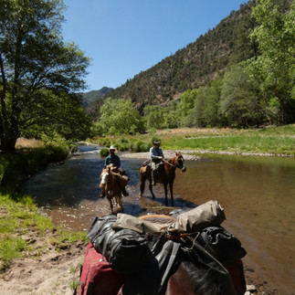
We have food with us for about 3 weeks, but the heat doesn't really make us want to eat. We have to drink a lot because it's very dry. A dip in the river is refreshing, but only lasts 30 minutes and then you're dusty and sticky again. The path in the canyon is very difficult for the horses and we don't make good progress. They only run about 3-4 km/h per hour when riding and leading them doesn't bring any higher speed, then they just let themselves be pulled. We follow the river to the hot springs of Gila. Later, at one of the many river crossings, Deets sinks into a mud hole and I fill both boots with fresh, cool water. We reach the RV park and get a beer from the campers, who enjoy showing their children the horses. After another 8 km we come to the second Hot Springs, where we miss the store where we wanted to buy supplies. After 46 km we reach Woody's Corral at the Gila Cliff Dwellings. The manager of the store happens to pass by and I ask him to provide us with hay for the horses. The next day he tells us about the beauty of the trail and provides us with some beer. Great guy.


20.5.
We wanted to see the Cliff Dwellings, but Ahi had another idea and he didn't like the prospect of having to stay with Mark without us. He bucked and ran, scattering his stuff all over the street and parking lot until Szolt and I came back. 2 belts ripped, a bag ripped, an hour later we were packed up again and rode on. Mark was now riding Deets as I didn't want to walk any longer as I couldn't get up on him without mounting help. The trail took us through the beautiful Bear Gorge and down to the Gila Middle Fork. We followed the river another 25 km upstream and set up camp after 38 km.


21.5.
The horse was fenced in by the river and had fresh alfalfa feed for the night. Her bells rang all night and I had to walk through the river twice at 6am in my swimming trunks to collect the fence. Refreshing, shame you can't save the cold for later in the day. We had a good start around 7.30am after breakfast and saddled the horse. On the way we passed a series of rapids and the trail took us over a small mountain because we couldn't go any further in the river. At one point Ahi decided to go alone, and after that I missed my SpotOn to let everyone know we were okay and alive. A little frustrated, I walked on without knowing where we had lost it. Luckily, Water Kat, a hiker from Anchorage, came down the trail and we asked if she could keep an eye out for the spot on and let my family know that we wouldn't have any communication for the next four days. She promised and delivered and even found the Spoton , in camp, where it must have slipped out of her pocket while packing. Today we made a total of 110 river crossings, bringing the total to 245 fords of the Gila River in three days. The going is tough for the horses and they are not progressing at their normal speed, so the day is getting long. We arrive at Trotter Camp and in the expansive field we fence the horses, put on their bells and start preparing our dinner. The horses no longer need to be tethered to the ground and are welcome to relax and eat as much as they like.


22.5.
The terrain opens up and the going gets easier. The horse has a good pace and we are making good progress this morning. It has become drier again, the river has become smaller and the vegetation has returned to cacti and the like. Around midday we reach Snowy Lake, where we are greeted by three fishermen who want to help us out with food, water, a campfire and beer. We agree. In the afternoon, the scoutmaster drives me to the ranger station and I can call Larkspur to inform the family. The batteries are all charged and we are ready for dinner. Then I find out that horses are not allowed on the campsite and we have to find another place where they can graze at night. It gets hectic until we have fenced the horses in again, eaten dinner and then gone up to meet the 3 men from Les Cruzes. Another couple from Europe has joined them, they got lost and ran out of gas. We spend a great evening with all the campers and go to bed late.


23.5.
We want to go to Pie Town to replenish our food supplies. We realize that we have too much hot food and not enough cold food like sausage and cheese. The weather is simply too hot for two meals a day, so we have to change our eating habits. We take the forest path as it provides shade. The Duplos work well, but the heavier version of the Duplos that Deets carries works best. We will have covered almost 500 km in these two weeks and we are doing well, judging by the distances we have covered. We decide to take the road as a large fire is sending its cloud of smoke in our direction. We make good progress, but the smoke, or rather the fire, worries my two colleagues and when we meet some firefighters in the middle of the forest, we discuss the various ways of getting around the spreading fire. As we can't find any water at the moment, the firemen let the horses drink from their 10-gallon barrels. We follow the road, but have to accept taking a long detour and making sure we avoid the fire area.
As we continue the next day, we see a lot of smoke rising on the horizon and to make some headway we want the horses to trot, but hey, they're not enthusiastic about it. So it takes some prodding on my part to get them going when the path we're taking takes us closer and closer to the smoking pillar in the distance. Mark is worried and wants to know what happens next and I can't give him an answer except to say not to worry. Because the fire is far away. We come to a fire station in the middle of the forest and it seems like all the firefighters have parked their cars there, but no one was around. We keep riding, looking for a well or a spring, and the CDT map said there was one about 5 km away. As we got closer, we came across a forest service truck guarding the road and making sure no one could drive into the fire zone, which had quadrupled in size during the night. While I discussed the road and directions with the chief of the forestry men, who came from all over the state and knew the area no better than I did, Mark and Szolt set off for the well and returned about an hour later without having found any water.
We plodded on and arrived at the road south of Highway 12. Amariollo Plain, an empty and very uninviting place. We found a corral where another sheriff was on the lookout to make sure no one would drive up the road to the fire. We had an interesting discussion with the second sheriff who had to spend the night guarding the road. He was very sure that there would be a war between the Democrats and the Republicans in the foreseeable future and explained why he would never give up his right to own a semi-automatic weapon.


24.6.
We rode all day through flat and rolling hills, passing a few wells where we could get water for ourselves and the horses. It was usually a greenish-yellowish broth that could only be enjoyed filtered. The days seemed to stretch into eternity. The blanket of smoke was still there, but the air was ok to breathe. After about 40 km we found another well with running water and let the horses drink, shortly after the rancher showed up and asked if we needed help. The valley was thick with smoke from the fire and we asked if he could get us a ride to highway 12 to shorten the last 15 km of the day. He agreed and 40 minutes. Later, we reached a cowboy church on Highway 12 where the owner of another farm allowed us to stay and even provided us with some hay.


25.5.
The next morning we got up at 4am and knew it would be a long walk to Pie Town where we would meet up with Keeyle who would bring us supplies. It took us about 22km to find water again and by 12 noon we had covered 45km. It took another 7 hours and 35km before we finally reached Pie Town at the end of our tether. We walked up to the very first house. The woman who worked in the garden there explained that the restaurants closed at 5pm, but she would get us water and hay. Another neighbor checked on us and offered that we could let our horses graze right behind his house. There was water and hay and so we set up camp at their place. They brought out beer in a cooler and by the time Keely arrived, she had brought pizza and all the supplies she wanted. It was a very pleasant evening with Mark and Keeyle staying at the toaster house. We had covered 50 miles today so Mark could make his appointment.


26.5.
The Toaster House is run by some locals and is a free place to sleep for CDT hikers. Showers and kitchen included. We met about five people hiking the Continental Divide Trail and exchanged information with them. For breakfast we headed to Pie Town Restaurant and there Pam was already up and about finding out about hay and where to graze the horses for another day. Mark had to get back to Albuquerque to take care of some paperwork, but his first task was to get the car fixed, which had a problem on the drive to Pie Town. Bob and Rose, two cowboys who had custody of their three grandchildren, lived on the Elk Ridge Ranch north of Pie Town. They had been cowboys all their lives and had incredible stories to tell. We enjoyed two days of their hospitality and were treated to some very tasty meals. Bob happens to be the chef at the Pie Town Restaurant. The horses were all rested, loaded onto the trailer and driven to Grants as there was no water for the next 50 miles ahead of us.


27.5.
We went shopping at Wallmart in Grands and I bought some presents for the kids. They were incredibly nice children and Rose, as their teacher, made sure that they had excellent grades. The daughter had made a cross out of twine for Zsolt and me and we were pleased that they chose some summer fabric. On Highway 17 we drove to the trailhead where the CDT to Grants begins and found that there was no water, just barren rock. We drove on to Coal Miners Campground in the hope of finding water there, but had no luck. We spent the night at an old rodeo grounds near Grants where we got water and the local rancher took us into town for dinner.
28.7.
In the morning we take the road up the hill where we come across the CDT. It is more pleasant to ride here in the shade of the large pine trees. The gates are all open and there is even water at a fountain. But as we get further on, the cattle troughs are all empty and even the artificial ponds are all dry. After another 30 km without water and after checking several tanks, we realize that we have a problem. We take a break and let the horses feed, hoping to reach another well about 15 km further on. We are just back on the road and following it north when a pick-up appears and we stop him. We ask if he knew where there was water. Turns out he was tasked with inspecting all the water sources to the north and he told us there was no chance of water for the next 60 km as far as registered tanks or wells were concerned.
We had to make a decision quickly. The water inspector had 10 liters of water with him, which he handed over to my colleagues and I drove back to Grants with the two of them to organize a trailer to pick up my friends and the horses the next morning. I arrived in Grants with the watermen at 10pm and checked into the local lodge.


30.5.
In the morning, I was trying to reach the ranger (Alvin Withehair Navajo Indian) and the sheriff to find out who could accompany us when I happened to call a coffee shop owned by the local rancher to get a cell phone number. Jerry was on the phone and he was the owner of the ranch, so he put me in touch with his brother Mark, who needed to send a cowboy to Antelope Wells anyway, so he would take me. Dan Graham, the cowboy/school teacher, picks me up at the lodge and drives another, faster way up to Antelope Wells. We find Mark and Szolt right away and they had no problems with the horses, as I had imagined in my sleepless dreams at the lodge. Dan told us that both the American, Colorado and Antelope wells had never run dry, but he knew of another hidden well (Escondito) that still had water last week. He said it was only a mile away. On the drive, which took about an hour, he told me he had to come here to look for a bull that had jumped the fence. So we drove to the hidden pond and found water for the horses. He unloaded his saddled horse from the hanger and set off in search of his bull, which seemed to me to be quite a difficult task given the size and hilly shape of the landscape. Unfortunately, he came back a few hours later without a bull, but with the information that it belonged to another neighbor. We loaded the 4 horses onto his own trailer and drove back down to Grants where he took us to the feed store to get some hay and to the gas station to get some beer. We spent the night in his barn where John, a friend of Dan's, showed up and promised to organize a trailer for the next day and call back in 10 minutes. I couldn't believe it when my phone rang at the appointed time and he told me we'd be picked up by John tomorrow at six. We had to fight Dan's dogs while we cooked our dinner and went to bed knowing we had done the right thing

31.5.
John drove into the Coral at 6.02am and explained that he loved being on time. We loaded our gear in the front compartment of his trailer and the horses in the back. It was a big, comfortable trailer and the horses were very happy to get in. It was a three-hour drive on a dirt road to Cuba, and when we got there we ate breakfast at the Cuban café. Other CDT hikers were there and word spread quickly that the trail through Santa Fee National Park was closed due to fire danger. Driving another 50 miles along the highway was not what we had in mind, so we decided to continue by trailer to get to Chama. Johne told us about all the different jobs he had and that he owned property here and there and that he had been married for almost 55 years.
In Chama we found a corral at Elk Ridge Lodge and unloaded the gear and horses. We went shopping and the woman at the lodge organized a forestry official named Marry to come by to talk to us about the trail up to Chama Pass and on to Wolf Creek Pass. We were informed that snow would not be a problem and that water and food should be plentiful. The beetle-damaged forest with lots of tree falls would be the bigger concern and we should just try our luck. We invited Mary over for our grilled steak dinner and enjoyed her company until bedtime.


1.6.
We walk 3 miles to the city center, where I get some cash from the ATM. Then we set off in the direction of CDT. After 17 km we reach the Cumbres Pass, where an old steam train stops. From there we take the lower path, as we won't find any water on the first part of the high route. We camp along a river, fence the horses and attach bells to them. Since we had a hearty meal for lunch (smoked hamburger patties, tortilla chips and nuts and fruit), we had some macaroni with beef, cheese and eggs for dinner. It's a cold and windy night out here in the bush, with clear skies .


2.6.
The road that would take us back to the CDT was a forest road, but ended in a path covered in dead beetle trees. It was like Miccado, and it was an arduous search for a passage around the fallen spires piled three or four high. It took us all morning to get back up the ridge (about 5 miles in as many hours), and when we finally made it, the views were fantastic. Marc used the drone and got some good shots. We still had 10 miles to go, but based on the GPS air miles, it's not easy to estimate the time needed. After about 3 hours and 9 km, we set up camp on a small hill with some trees at 3600 m to give us some shelter from the wind.


3.6.
In the evening, a New Zealand hiker came along the trail and told us about the weather forecast for the next day with 80% heavy thunderstorms, snow and hail showers. When we got up after a surprisingly warm night, we realized that thick clouds covered the sky and although the water in the swamp was frozen, it started to rain. We packed up and as it was only drizzling, we hesitated to put on rain gear. After about 2 hours it started to really rain and when we reached the place we were heading to yesterday, we changed our plans and decided to hike down the next valley to avoid the heavy lightning and thunderstorms up here on the ridge. It was a long, 40 km descent where we met a couple of hikers who told us that we would find a resort at the end of the trail if we continued on to the lake, so we decided to do just that. We were glad we did, as Ahi had lost both hind shoes and we had to re-shoe him, but didn't have the right size for him. It had been raining, hailing and snowing all day and we were pretty soaked. After arriving at the resort, finding a place for the horses and booking a cabin, we checked in to dry our clothes. After a hearty meal in the restaurant, I found a phone in the reception .nken. We reached Kristie Hefling (a true trail angel) and she got us a pair of shoes from her farrier and promised to bring them to us in Pretoro.


4.6.
We were invited to camp by the Texas neighbors and served beer and venison that the 8 year old boy had shot earlier in the spring. Great food and great storytelling time with the family of 8 who came here to go fishing. We repaired bags and our food boxes, some of which were torn. I worked on my blog until Kristy and her friend arrived after lunch. We sat down with them and she insisted on not getting paid for the delivery. I persuaded them to at least buy her lunch and then we set to work nailing the fittings on Ahi, who held still with no problems. The weather seems to have cleared up and the horses are happy in the fenced area.


5.6.
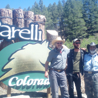
We ride up to Summit Pass and Elkwood Pass. The trail is covered in fallen beetle trees (we were told 80% of the forest in the area was affected), so we decided to follow the 4-wheeler trail, with the Garmin later showing me a way to get back to the CDT. Along the way we meet four guys from Pagosa Springs who were all excited about our trip and one of them tells us we need to check out Pat Parelli's house in Pagosa. Juergen lives there and so does Kristie and when it turns out that the trail shown on the Garmin is just a mystical stick trail that is impossible for horses, the decision is made to go to Pagosa. When the East Fork River flows into a wider valley, we camp at a former campground and sleep under birch trees. The horses are fenced in the meadow directly behind us, and at night an elk appears, frustrated that he can't graze in his meadow.


6.6.
We follow the East Fork River and it is a beautiful valley. We come across an old cabin on the right and see people coming down to the fence. It's Mimi, the owner, who lives in California and is just coming here for the summer. She allows us to use her phone so I can call Kristie from BCHM again, and she organizes, without hesitation, a trailer and truck to take us to Pagosa a short time later. We meet John and his wife 7 miles east of Highway 160, load up and drive to Kristie's house where we can put the horses in her field and sleep in her trailer.


7.6.
John picks us up for breakfast in the morning and takes us to the saddlery so that we can have our things repaired and replaced. In the afternoon we visit Parelli's Place and miss Pat by just a few minutes. Jürgen and Anita take us into town and to their place in the mountains (an incredible place) and later we all meet up at the steakhouse "The Buck Stops Here" where we try honey bacon.


8.6.
Again, Kristie, our personal hero from BCHM, has organized a trailer for us to take us to Wolf Creek Pass, where we say goodbye to Nancy and Kristie and mount our horses to lead them up the CDT trail at 1pm. The trail takes us right up to the tree line and there is very little snow. We hike along the trail and only have to go around a few snowfields. The landscape is breathtaking and we enjoy the solitude of the trail. At 4.30 a.m. we find a good place to camp in a large meadow with lovely grass for the horses.


9.6.
The horses are not enthusiastic about the new energy pellets we have for them. But they eat it up. The trail takes us back above the tree line and we find the Creed Cutoff after passing a few lakes. We meet a fisherman who predicts that I won't be able to walk safely through the snow in my boots, without crampons and ice axe. And I should definitely not try to go as far as Knifeds Edge, because horses might not be able to get through. Okay, it's still a long way to go, so I'm not worried about that. The path zigzags up the mountain and we cross a few passes. The highest is at 3930 m or 12900 feet. From there we take the Ivy Creek Trail and descend to Goos Lake, where we camp for the night. Knifes Edge is another 8 miles to the west. We won't get there... the trail will be closed in two days.
Last day with Mark on the trail. The day after tomorrow he will return to Albuequerque
the day after tomorrow. Antonion will replace him. He confirmed it today. I'm sorry to see him go. It was great riding with him. Mark, anytime again... I promise...


10.6. The lake is beautifully nestled in a small valley and there is still snow on the edges of the lake. The further we descend, the more difficult it becomes because we encounter so many beetle forests. On the small path, it is difficult to go around the fallen trees, so we have to fight our way through a few times. Hard work with only a small handsaw. There were about 120 trees before we reached the valley floor and could ride again. It took us more than 4 hours to cover the 12 km. We reached the Rio Grande about 15 km before Creede and camped right there by the river.


11.6.
Creede is a small mining town with about 300 permanent residents, 3000 in the summer and 10,000 on the 4th of July. It stretches over the entire valley of 10 miles. The pellets have an interesting effect on our horses. In the morning, Rodeo runs off, not to be caught no matter what. Ahi follows him, but soon he is tired and can be caught. Luckily the others were on a par, so we only had to deal with one horse. The horses are finally saddled and we ride up the road, past private homes, and I remember the night before when a driver in a truck told me about a campground just a few miles up the road. Well, a few miles here is actually like an hour ride on a horse and it's about 5km. We passed the campground and came across the first signs of civilization like mailboxes and RVs, and suddenly Ahi got the idea not to pass them because they might attack him. We get to the information center and ask where we could park the horses, but the lady, who is so helpful and nice, can't find any useful information. We learn from the estate agent that horses are not allowed within the city limits and about 3 hours later we are back south of the city, on the Rio Grande, where Ray, a man from the city, has shown us an abandoned park where we can let the horses graze. I organized some hay for the horses and we were camped by the river when a friend of Antonio's, who is supposed to replace Mark, came by and asked if we needed help. We declined and asked if he could pick us up the next morning at 11am at the place Antonio had mentioned. At ten my wife Kathy came to bring supplies and at twelve we were expecting Keeyle. We all met up and drove to the place where Justin had brought the horses. There are a couple of cabins and we were able to rent one. Dinner at the stake house was excellent.


12.6.
Two hours before his planned arrival, Antonio informs us that he won't be joining us. Well, that brings the whole thing to a standstill. We can't go on with 4 horses, and it doesn't sound good to just leave one of them in unknown hands. On top of that, the problem is that our communication skills are at 0. We can only talk on the phone via the internet. Mark is definitely going back to Albuequerque where he has to start his life over. We need some time to get organized, so we decide to return to Larkspur and see what we can come up with. I need better mobile phone service, the Gimbel needs to be repaired and we need to find a third driver. Simone from Germany would be a possible candidate. let's see what comes of it.
Whatever it will be, we will ride again on June 22. Szolt also needs a break, he hasn't eaten much and has no appetite. I hope a few days rest will improve this situation too.
22.6.
Szolt is feeling better again and we have Simone with us for a week. Gets us going again. Kiowa has developed a blister that won't burst, so we decided to go to the vet when he wants to lance it. We drove to his place and surprised him by ringing his doorbell at 8am office hours. He explained it had never happened to him before, but an hour later we were on our way again, no lancing but with 10 days of antibiotics. We drove to Johns Quarter Circle Ranch, north of Creede, and stayed there for the night.
23.6.
We ride north on off-road trails over hilly and wooded country. It's easy and there's plenty of water and grass. The blister in the Kiowa movie theater is gone and we are happy that it is getting better so well. After 35 km we find a good resting place with plenty of grass and set up camp. Simone, who is with us, rides Deets and is doing well.
24.6.
As usual, we had fenced off a pasture for the horses for the night and let them run around freely outside the fence with their bells so that we could hear them. As we put down our sleeping bags for the night and prepared our dinner of freeze-dried food. The horses didn't stay close as usual but moved further up the mountain. They didn't seem to like the grass here. We moved the fence to the area where they had been grazing and made it as big as possible. At last the horses were happy.
We each have a ground sheet that doubles as a rain poncho, the padding for the horses on top and the blankets, a down mat, 5 cm thick and weighing about 700 grams. I also have a summer sleeping bag (which you can pull over the winter sleeping bag) and my wool poncho, which serves as a blanket on the horse during the day. We use the bag roll as a headrest and support it with the saddle.
I didn't sleep very well as I always had an open ear for the horses' bells. Their departure last night left me haunted in my dreams. And it was cold. In the morning, my second sleeping bag was covered in frozen mist.
After breakfast we had to climb immediately and rode all day from peak to peak (about 10 of them) and every now and then we met a few off-road bikers who waited very politely as we passed. After about six hours of hiking above the tree line, we descended into a valley where we found a spring and let the horses drink. Further down was a stream and a beautiful floodplain where we set up camp again. As usual, the horses grazed outside the fence (to save food for the night). We were cooking our dinner when four off-road bikers roared past and the horses galloped up the hill in fright. I chased after them, Szolt and Simone followed me, and I found them again at the spring where we had watered them before, about 6 km further up the hill. Halfway up the hill, Szolt and Simone arrived and we brought the horses back down to the camp. They were put in the fence and we could finally sit down to eat. We had covered about 40 km today.
25.6.
In the morning we see smoke on the horizon. We lead the horses down the stream in the valley and when we reach the cross valley, we climb back up and ride along a small path that is lined with beautiful spring flowers in blue, white, yellow and red all along the way. It's like riding through a park full of flowers. We jog a lot along the way, as it's over 60 km to Monarch Pass today. When we reach the pass, we try to get a beer, but alcohol is not for sale on BLM land. We follow an old ski hill down to the campground and find a place for the horses right next to the campground, where we will take a day off.
26.6. The camp caretaker doesn't really know how to handle the horse situation, but since the camp is only on one part of the road, the other side being BLM land, I am able to convince him that the horses can stay on the other side. They drive me down to the lodge and take Simone to the next town so she can get a rental car and we can pick up the trailer and truck at Johns Circle Ranch.
The lodge is nice and you can have breakfast there and use the Wi-Fi for free. I work on the maps, download information about the route and upload Facebook data. About 2 hours later, I receive a message from Simone that she can't rent a car because she can't get insurance cover from the car rental company. (Only the big ones have insurance for sale). After 4 hours of phone calls and running around in 30 degree temperatures, Simone finally rents a 15 foot, 7.5 ton Uhaul truck so we can pick up our car at Circle Ranch.
27.6.
Simone drives our truck and trailer to our next destination, the Twin Lakes, which we should reach in about 3 days. In the morning we saddle Ahi as a packhorse, as I am riding Deets. While Szolt is saddling him, he pulls the back chinch too far back and Ahi kicks him and hits him on both knees. He is still wearing his iron shoes, which is now causing Szolt a lot of pain. Nevertheless, we can continue, but Szolt complains about the pain, which is now spreading to his groin. Not a good start... We load up all the electronics that were charged at the lodge and ride back up the steep mountainside to the CDT. We cross two mountain passes today, 3700 m (12140 f) and 3560 m high. And although the paths are in excellent condition, we have to go around a few trees. At one point Ahi gets stuck between two trees and instead of waiting for help, he makes his way through and tears off one of the two side bags. We have to fix them with ropes and it takes about 30 minutes to get everything working again. We pass the house Simone told us about and when we dismount, we find a truck parked by the lake on an off-road trail. The truck from Texas has made it here with three fishermen we saw earlier. We won't make it to Mirror Lake as planned, but in the next valley we find good grassy areas and water, so we decide to camp right there. In the evening we meet a lady from Denver who is on her way south (Sobo) and decides to camp nearby.
28.6.
Tin Cup Pass
Following the GPS, we ride up the trail to Tin Cup Pass and then take the road down. Somewhere I miss the CDT trail and we end up down in the village of Tin Cup. We're not too upset about it, because at least we get a burger and a Coke. A driver stops and wants to give us money to buy food for the horses. I don't quite understand why and thankfully decline. We follow the road and then find a trail that takes us back to the CDT.
29.6.
Yesterday we rode 35 km to Clear Creek, although Szolt had pain in his leg. We head out of the valley until we hit a steep climb. It winds through the forest up to Anna Pass at 3830m. At the very top we have to cross a snowfield about 30 feet high. I go first with Rode and let the others follow, finding their way through the snow individually. The path leads steeply downhill via some rock slides and then drops down to the lake. Ahi decides to take a different path down, and only when he sees the horses on the other side of the lake does he find his way back. Soon we are on the road and Deets jogs all the way down until the trail heads north again to Twin Lakes. There's a beaver pond, we let the horses graze and drink while I search the river valley, which is full of bush, for a place to let them graze. I find a patch of dried up swamp where there is plenty of new and old grass and we corral the horses there. We've just finished setting up camp and setting up the burner to heat water when the three peds run up the old riverbank to the road and trot back to the beaver dam. I follow them as they run, while Zsolt turns off the gas and runs after them, fetching the ropes. When I caught them, it was Deets, who obviously didn't have enough to drink, as he was the leader of the group. We brought them back, doubled the fence and put new batteries in the fence set.
30.6.
The night was quiet, the horses were all lying on the thick grass bed and the moon was bright as ever. In the morning we climbed up the mountainside, crossed the overpass and descended back into the Twin Lakes valley. It was supposed to be 8 miles, but as usual it took much longer and we reached the village after about 20 km and around 12 noon. We drove to where the trailer was supposed to be parked but couldn't find it. I returned to the village to find out online where the trailer was parked. I found it and drove to Zsolt and the horses. He was in pain so we decided to load up the trailer and drive back to Larkspur to give Zsolt a chance to recover his leg.
Comments